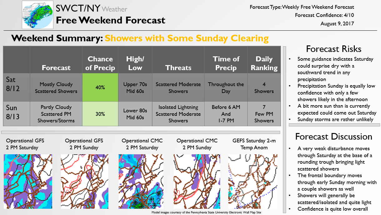
by SWCT/NY Weather | Aug 9, 2017 | Public
The below forecast is issued once a week on Wednesdays for free, outlining expected weather conditions for the upcoming weekend. We note that the current forecast is rather low confidence due to a weak storm system sliding nearby on Saturday, meaning this forecast may change over the next few days but no significant impacts this weekend appear likely regardless at this time.
by SWCT/NY Weather | Aug 2, 2017 | Public
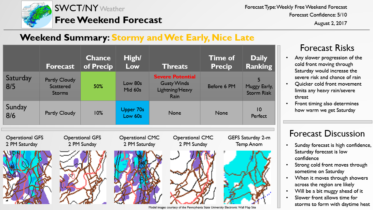
The below forecast is issued once a week on Wednesdays for free, outlining expected weather conditions for the upcoming weekend.
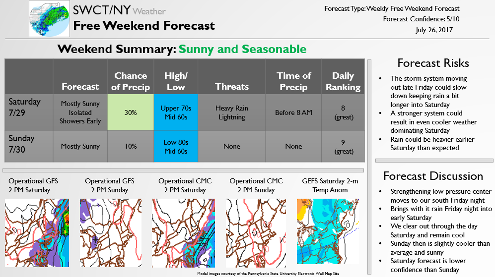
by SWCT/NY Weather | Jul 26, 2017 | Public
The below forecast is issued once a week on Wednesdays for free, outlining expected weather conditions for the upcoming weekend.
by SWCT/NY Weather | Jul 26, 2017 | Public
Hello and welcome to the newly upgraded SWCT/NY Weather site! Over the past few weeks the site has undergone a significant amount of changes in order to improve the quality for both Premium subscribers and those coming just for the occasional free forecast.
We wanted to take this time to introduce you to what the new site has to offer. Over the coming weeks and months ahead of the winter season we may continue to roll out new functionality for users, but a new report schedule is now set. The first change that some of you may have noticed is an increase in the activity of our Twitter account, @SWCTWeather. This account will now feature weather analysis daily so is definitely worth a follow if you don’t follow already!
More consistent free content will also be coming to the website as well. Every Wednesday we will be publishing a “Weekend Look” forecast that lets you know what we are expecting for the weekend. The first one will be posted later today and will look at the coming weekend. It will include an analysis of what risks there are to the forecast, what types of weekend activities may be best in the weather, what the chances of precipitation and temperatures look like, and how confident the forecast is. Additionally, during any winter weather events we will be posting free forecasts ahead of the storm to warn of wintry accumulations, precipitation types, and timing of storms. These will generally be posted about 36 hours before the worst of the storm is expected to hit, and updated as the storm comes closer into focus. We will occasionally release snippets of Premium reports also analyzing future storms that look to hit the area as well. For those that are interested, all Free content will also be sent over our Free mailing list (along with occasional previews of some Premium content as well that will only be available to those on the mailing list!) so signing up for this new Free mailing list is certainly worth your time!
For Premium subscribers we will be releasing new report formats to ensure quick and easy understanding of all weather threats over the next few weeks. The largest change that will be noticed right away will be the inclusion of Daily Reports that outline “threat days” over the coming two weeks. This analysis will highlight when significant chances of rain or storms are appearing on guidance, and will analyze temperature trends both in the short-term on an in depth basis and in the long-term on a more general basis. The reports (seen on the Samples page) will be quickly and easily digestible, and will also come with a paragraph of commentary on what is the most important part of the forecast, what is lowest confidence, and what has changed since yesterday. Along with these will be specialized reports ahead of any severe weather threat or Nor’ Easter that outlines specifically what the threats are to the region, what the timing of any threat will be, and what the best course of action would be in preparing for these storm threats. If necessary they will go in great detail about potential power outage or wind damage threats, though such events only occur a couple times a year.
There will still certainly be some remnants of the older site on here, however. We will continue to offer Premium clients detailed travel and school analysis around winter storms. Our most detailed Premium reports will focus on winter weather, in which we will analyze everything from timing of precipitation types to confidence in accumulation ranges, ensuring that school delay and closure percentages are provided for subsets of every county we forecast for. The result will be the most compact detailed analysis yet of winter storms, allowing Premium subscribers to quickly and easily see everything they could possibly need to know about impending winter weather. These three page reports start first with school/travel impacts, then go into timing and accumulation, and end with model images and a discussion on forecast risks and confidence (again, these can be seen in the sample section). Depending on the severity and duration of the storm the templates may be tweaked, but all will follow this general style, ensuring that all potential questions about winter storms are answered.
What all this means, though, is that you should bookmark swctweather.com now to ensure you continue receiving the latest weather information for the SWCT/NY Weather. For the first time in over four years this site is going to be regularly maintained year-round, providing weather analysis constantly to subscribers and visitors alike. We are greatly looking forward to this new chapter, and are excited for you to join us!
-The SWCT/NY Weather Team
(A subsidiary of Bespoke Weather Services)
PS. Below you will find all of our older Free posts dating back from the last winter. We’ve kept all older forecasts on the site as well in case you feel like going back and verifying any of our previous calls!
by swctweather | Mar 14, 2017 | Public
This forecast was sent out to Premium subscribers just past 1 AM updating on the potential for more snow/sleet to mix in with the storm. The update is now shared below:
Model guidance tonight has continued recent westward shifts with the storm system overnight into tomorrow. Light snow will break out across the region in the next few hours if it has not already, and by 4 AM steady snow is expected. Heavy snow is expected by 5 or 6 AM that will continue through the morning.
Most model guidance shows a high chance of mixing with sleet, freezing rain, or even rain sometime between 9 AM and 1 PM tomorrow. This will be at the peak of the storm and limit overall snowfall accumulations. Recent estimates have me looking more at the 8-16 inch range across coastal areas where we mix earlier and 10-18 inches further inland where snow holds on longer. The storm between 2-5 PM likely ends as a burst of snow as well as the back end moves through. However, from the late morning into the early aftenoon a mix of sleet/feezing rain/rain is quite likely to mix in with the snow, limiting overall snowfall accumulations.
The result is that I see current National Weather Service forecasts as a bit overdone for the region giving this recent mixing risk. Additionally, some icy conditions could easily linger into Wednesday, but lower accumulations lessen the risk of significant impacts lingering into Wednesday. The risk for serious travel impacts from wintry weather and wind tomorrow still remain, but a chance to other wintry weather may keep it from being as serious.
Another update will come tomorrow morning updating on the risk of lingering travel and school impacts into Wednesday. The forecast is a bit lower confidence as models are divded as to whether we turn more to freezing rain or sleet. Both will make travel terrible tomorrow afternoon into the evening, but the impacts from there are more uncertain.
by swctweather | Mar 13, 2017 | Public
Below is the latest forecast for the upcoming blizzard:
Mostly sunny skies dominate for the rest of the day with high temperatures in the low 30s. Overnight clouds rapidly increase, with a chance of snow arriving after midnight. Snow begins light between 1 and 3 AM across the region, picking up in intensity by 4 or 5 AM by which point all travel will become dangerous and snowfall rates above an inch per hour can be expected.
Heaviest snow tomorrow falls between 7 AM and 12 PM with high tempeatures in the low 30s. The heaviest snowfall rates could peak out at 3-4 inches per hour during this timeframe, at which points thundersnow would be a real possibility as well. Between 9 AM and 12 PM sleet and freezing rain could mix in with snow across coastal regions as warmth moves in aloft. This will compact snow a bit and keep snowfall ratios around 10:1, if even a bit less. Snow quickly tapers off between 12 and 4 PM across the region, with lingering snow showers into the evening.
We could see a couple lingering snow showers Tuesday night on the backside of the storm as winds remain breezy. Low temperatures drop into the upper teens with wind chills dropping into single digits, especially inland.
Wednesday looks to start mostly cloudy with maybe a few lingering snow showers, but most accumulating snow should have already ended. High temperatures get into the low 30s as we clear out.
Model agreement on the storm is stronger on very significant snowfall accumulations across the region. No longer does there appear to be that much of a risk of the storm sliding to our east, meaning we should see the heaviest precipitation at least partially across the region. This means that there are two main things to track: banding and mixing. Most models show 1.5-2.5 inches of QPF across the region, which on a 10:1 ratio with the sun angle in March that would lead to 15-25 inches. However, there is going to be a risk of mixing across coastal areas, which could limit accumulations to around 12 inches. That said, 12 inches across all guidance looks a virtual guarantee, with a maximum of 24-25 inches in the heaviest banding. The new forecast now is for 12-20 inches of snow widespread across the region, with isolated amounts to 24 inches in the heaviest banding possible. That banding is most likely to be further inland, as now it appears that accumulations may be a bit more limited by the coast where there will be some mixing with sleet/freezing rain at the peak of the storm. The storm is fast moving enough that more than 2 feet looks unlikely, but even that would be enough to cause enormous problems.
As mentioned previously, the two things to focus on are mixing and banding. If at the peak of the storm there is mixing along coastal regions, accumulations from 12-16 inches are more likely than from 16-20+ inches. If there is no mixing at all we could even see more than 20-24 inches where the heaviest pecipitation occurs, but at least some sleet looks possible. It will be important to track the mid-level atmospheric low pressure center that will move near the region and determine how far inland warmer air gets. It is impossible to know the exact orientation until the storm really gets going, as short-range models tend to struggle with such features. The same can be said with banding, which is hard to identify until inside of 12 hours.
Wind gusts in the storm look to get up to near 50 mph. Luckily, surface temperatures in the upper 20s/lower 30s through much of the storm will keep the snow from being quite as sticky, so concerns about downed tree limbs are not quite as high, but some downed limbs are possible. Isolated power outages by the coast are also possible Tuesday. The strongest winds will be near the coast from Tuesday mid/late-morning through the evening as the storm rapidly intensifies. Moderate coastal flooding is likely as well as water gets pushed up along the coast, as the storm looks likely to be very strong. However, winds will be worse across the Mass coast than in SWCT/NY. Winds peak in intensity between 9 and 11 AM when most power outages would occur.
The National Weather Service has upgraded the entire region to a Blizzard Warning, as expected. They are similarly calling for 12-20 inches of snow now, with decent agreement overall. It is hard to see significant changes to the forecast unless there is a warmer trend with more mixing that would limit accumulations. Otherwise, at least a foot of snow looks like a guarantee with impacts lingering into Wednesday.