by SWCT/NY Weather | Jan 3, 2018 | Public
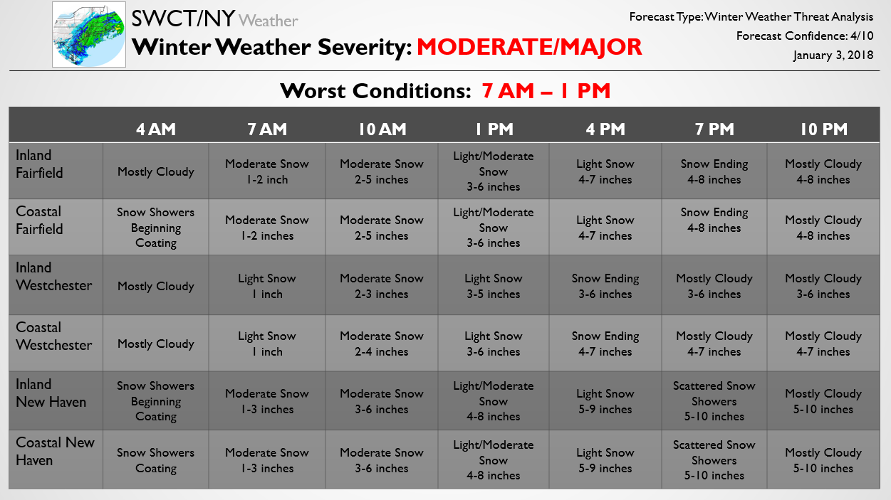
The below forecast is one piece of our Storm Threat Alert published at 10 AM for Premium subscribers. The standard Storm Threat Alert is 3 pages, outlining school/travel impacts as well as accumulation, timing, and offering a forecast discussion. The below Update shows the updated accumulation and timing expectations for the storm across the region. Confidence still sits a bit below average with this storm as there looks to be a rather sharp snowfall gradient across the region, and any small shift in the precipitation shield could have a rather significant impact on accumulations. It is likely that this forecast will continue to be revised through the evening.
Additionally, we are worried about gusty winds with the storm, with wind gusts up to 45 mph at the coast and 40 mph or so inland. This could result in isolated power outages across the region. Though not widespread, extreme cold will move in behind the storm, with low temperatures in the single digits tomorrow night and potentially below 0 Friday night. Sub-zero wind chills both nights are possible as well. Please have a plan in place in case you lose power; though it is not likely, it is a threat we are currently monitoring due to these wind gusts.
We will continue to pass along each Update as the forecast is tweaked ahead of this winter storm. To get the full Updates on the storm in advance and see forecast school impacts you can subscribe here, otherwise be sure to stay tuned as we will pass along additional Free updates today.

by SWCT/NY Weather | Jan 2, 2018 | Public
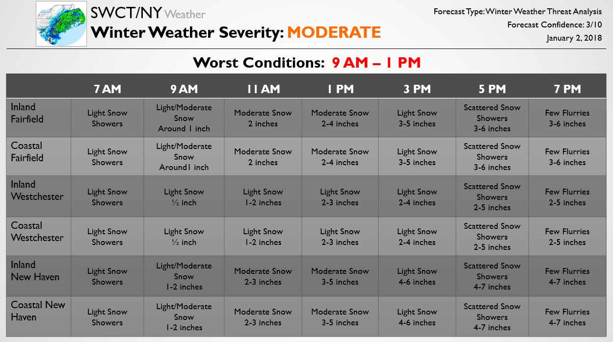
The below forecast is one piece of our Storm Threat Alert published earlier today for Premium subscribers. The standard Storm Threat Alert is 3 pages, outlining school/travel impacts as well as accumulation, timing, and offering a forecast discussion. Below we show the preliminary expectation for accumulation and timing for the snow threat on Thursday. It should be emphasized that this forecast is very preliminary, however, as the region looks to see a tight gradient between steady snow across eastern portions and lighter snow across western portions. Additionally, there remain solid timing differences between modeling guidance that need to be worked out tomorrow.
We will continue to pass along forecast updates as they come. To get the first Updates on the storm and see forecast school impacts you can subscribe here, otherwise stay tuned as we will pass along broader Free forecasts for the system as it approaches.

by SWCT/NY Weather | Dec 27, 2017 | Public
The below forecast is updated once a week on Wednesday for free, showing our thoughts on the upcoming weekend. Confidence in the forecast this week is just a bit below average as we are tracking a weak storm system that may track across the region later on Saturday. There is a risk for light snow on Saturday accordingly, though the exact timing and amount remains unclear. Some models show a quick coating to up to an inch, while other models show a fluffy 2-4 inches. At this point it does not look all that significant, but these small systems can often have surprises or shift quickly, so we will be keeping a close eye on it. To get daily updates on this storm threat and some of the longer-range snow threats we are watching try out a Premium subscription here, otherwise stay tuned as we will pass along broader Free forecasts for these storms as they approach too.

by SWCT/NY Weather | Dec 20, 2017 | Public
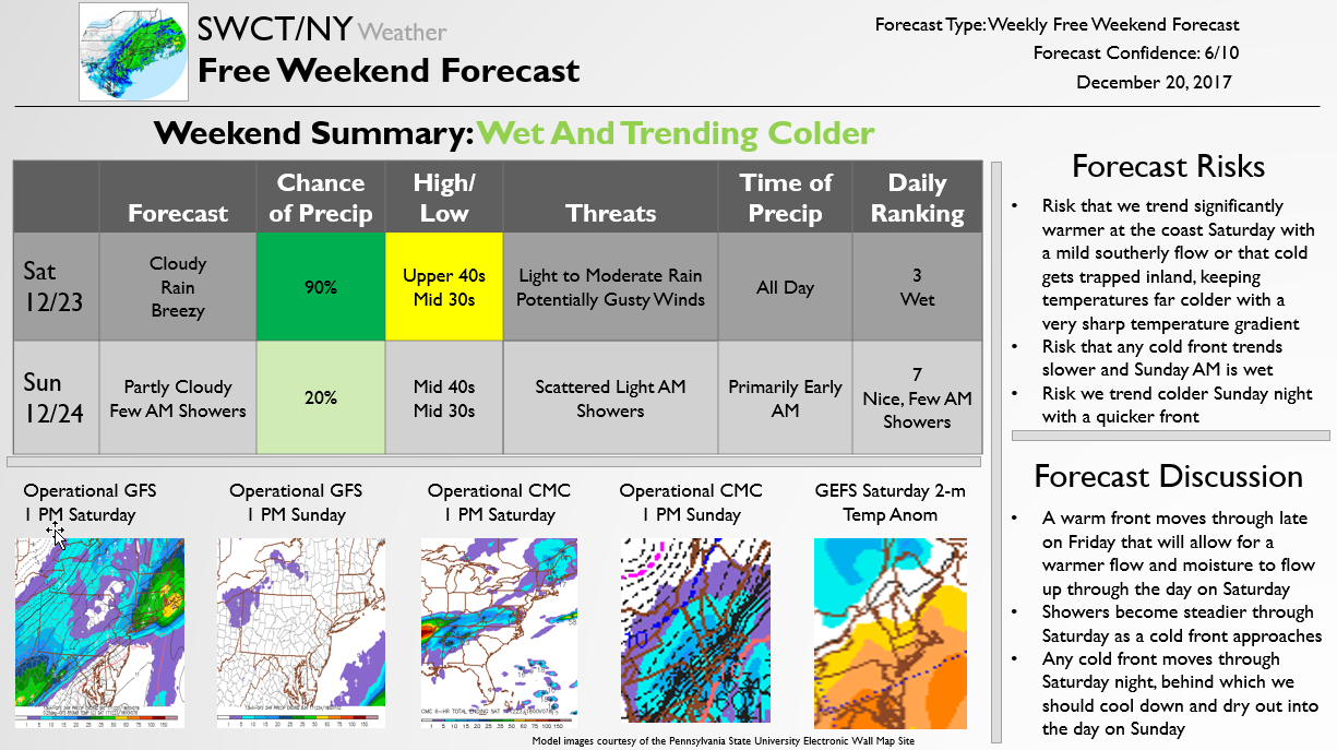
The below forecast is published for free once a week on Wednesdays looking ahead to the upcoming weekend. The forecast this week is complicated by the expectation for moderate rain through the day on Saturday. Sunday is looking like the better of the two days this weekend, with showers clearing out and colder, drier air moving in. Premium subscribers will be receiving updates on timing of the Saturday rain through the week while we additionally track a chance of rain or snow on Christmas Day that could disrupt travel. It is too early to know how significant any storm threat Christmas Day would be or whether it will be wet or wintry, but a number of options are on the table and impacts are looking increasingly likely, so be sure to stay tuned!

by SWCT/NY Weather | Dec 15, 2017 | Public
Below is one piece of the Free Forecast that was passed along earlier today to Premium subscribers on a light snow threat this afternoon. We will pass along additional updates as they come out with this surprise light snow event moving in this afternoon.

by SWCT/NY Weather | Dec 13, 2017 | Public
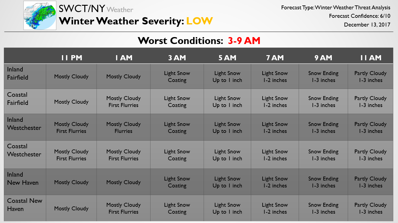
The below forecast is a piece of our Free forecast that we just sent out to Premium subscribers. To view the full forecast, which includes estimates for school delays and closures across the region, forecast risks, worst travel times, model images, and a detailed forecast discussion, try out a subscription here. Otherwise, we’ll continue to post the latest snow accumulation forecast changes here.
