Good afternoon.
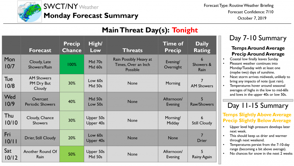
I hope you had a nice weekend and were able to enjoy the spectacular weather on Saturday! Unfortunately, our forecast for this week is looking a bit unpleasant as an area of low pressure meanders slowly off the New Jersey coastline. That being said, no significant weather-related disruptions are expected at any point during the next two weeks.
A cold front will cross the region this evening, bringing a round of steady rain. While 1-1.5” of rain is likely to fall as a result of this front, the ground is dry enough that we’re not expecting any flooding-related issues. The rain combined with thick cloud cover will keep temps on the warmer side with lows in the mid 50’s. This front will be slow to leave the region tomorrow morning, and I can’t rule out a few stray showers for the morning commute. The afternoon should be drier, but it doesn’t look like we’ll get much if any sunshine. Expect highs in the low 60’s.
Much of this week will be characterized by overcast skies, cool temps, and periodic rain as a coastal low meanders slowly to our southeast. Wednesday will feature the best chance of showers between tomorrow and next weekend along with the coolest temps in the mid 50’s. Thursday will be a little drier, but clouds will continue to stick around. High temps won’t be meaningfully different from Wednesday, likely just two or three degrees warmer. Friday appears to be the driest day of the week, but residual mid/upper level moisture will keep the overcast skies in place along with the generally cool temps. Another round of rain will arrive on Saturday as the coastal storm finally gets picked up by the next cold front approaching from the west. For the entire mid/late week period, a steady NNE breeze will add to the dreary feeling provided by the cool temps and cloudy skies.
That pesky storm will finally be out of our hair by Sunday though the exact timing of its departure could shift around by 12 hours or so. We’ll get some well-deserved sunshine Monday into Tuesday before our next storm system approaches Wednesday with another round of rain. Overall, temps look to be right around average, which is mid 60’s during the day and low 50’s at night.
The 11-15 day period looks warmer and drier as upper level ridging builds across the East Coast. You might find it interesting to note that this ridge will develop directly in response to the recurvature of Super Typhoon Hagibis which is currently moving through the Mariana Islands in the Western Pacific. We often see impacts to our local weather from Western Pacific typhoons this time of year, and it’s a neat reminder that everything in our atmosphere is connected one way or another.
Jacob will have your next update on Wednesday.
-Jack