by SWCT/NY Weather | Mar 20, 2018 | Public
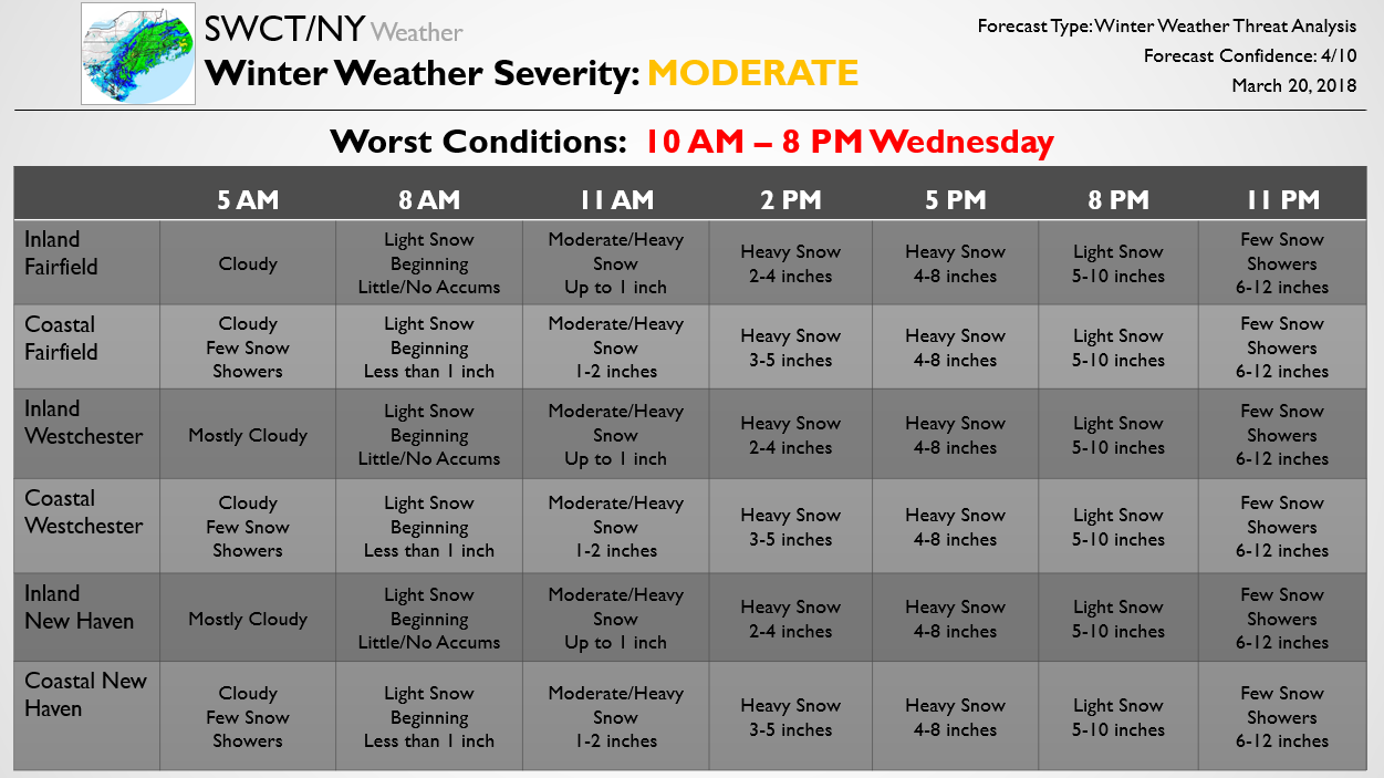
The below forecast is one piece of a Storm Threat Alert sent out to our Premium members earlier for the storm. That Alert also includes a more detailed discussion along with forecast risks, school closure/early dismissal percentage chances, and details on potential travel impacts. As can be seen in our below forecast, a rather significant storm is forecast for the region with the entire region likely to see at least half a foot of snow. Amounts of a foot are possible across the coast and primarily western areas, where models show precipitation heaviest, though the entire region could get into the heaviest banding and see impressive accumulations. There are significant risks in both directions here; some short-term models show more impressive banding that could bring accumulations over a foot to much of the region. Other guidance shows dry air winning out inland and potentially lower accumulations as well, so there are risks in both directions. We have a number Updates on the way for Premium subscribers and will pass along any significant changes to the accumulation forecast as well. We are continuing to run our March deal which is half off your first year on SWCT/NY Premium; sign up for that here!

by SWCT/NY Weather | Mar 14, 2018 | Public
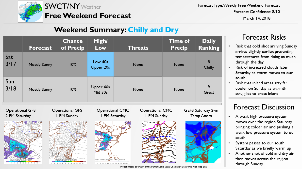
The below Free Weekend Look breaks down the weekend forecast every Wednesday, discussing forecast risks and expectations.

by SWCT/NY Weather | Mar 12, 2018 | Public
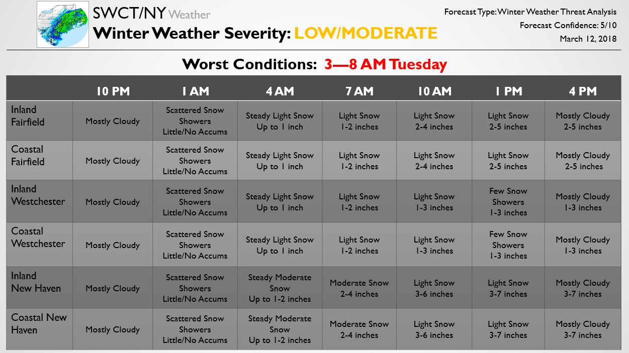
The below forecast is part of a much larger update that recently went out to Premium subscribers detailing expected school and travel impacts from the storm and discussing the latest risks as to how the forecast can trend, where risks for the worst snow accumulations are, and the like. The below piece again outlines our updated accumulations and forecast timing across the region. From the last update we have generally increased forecast accumulations modestly across inland areas, where recent model guidance shows risk for a bit more precipitation than we previously had. We will have another Premium Update for clients at 10 PM that will give our final call on accumulations and school/travel impacts for the region tomorrow. To view that, try out a Premium subscription here. If there are any major changes to the forecast overnight we will pass them along here as well.
by SWCT/NY Weather | Mar 12, 2018 | Public
The below forecast is one piece of the Update Premium subscribers got a few hours ago detailing expected school and travel impacts from a Nor’ Easter tonight into tomorrow. Below we outline timing, precipitation type, and expected accumulations across the region. We will continue to pass along any timing and accumulation forecast adjustments through the day as a sharp snowfall gradient looks to set up across the region, with the heaviest snow across eastern areas and the lightest snow across western areas. The large snow accumulation ranges in each county are due to expected tight gradients, with eastern areas of each county likely receiving the most snow and western areas likely receiving the least snow, though there will be some deviations within any banding. For more details on how schools are likely to be impacted tomorrow and the latest forecasts/analysis, try out a Premium subscription here.

by SWCT/NY Weather | Mar 6, 2018 | Public
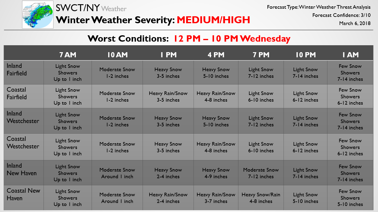
This below Forecast Update is part of a briefing package sent out earlier to Premium subscribers. It details our latest expectations for precipitation type, storm timing, and accumulations based on region across SWCT/NY. We will have another Premium Update tonight but will pass along significant changes to our forecast for Free as well. However, Premium forecasts go much further in depth and cover all angles of the storm while also looking at potential school impacts into the day on Thursday. We are running a special where you get 50% off your first year of SWCT/NY Premium if you sign up here, so try it out!

by SWCT/NY Weather | Mar 6, 2018 | Public
The below Free Update is one piece of a forecast Update we compiled earlier for Premium subscribers that outlined school/travel impacts, forecast risks, and included a detailed discussion. Confidence with this system thus far remains below average due to risks that rain mixes in along coastal areas, severely holding down snow accumulations. This could mean that some coastal areas struggle to even see 5-6 inches of snow, with rain that falls melting any snow, especially with surface temperatures above freezing. The entire region should see a period of heavy snow, and if there is no mixing then significant snow accumulations are expected, but there remain large uncertainties that will need to be determined tonight.
For those that want more detailed and consistent storm updates, for a limited time we are offering 50% off all Premium subscriptions for the first year using the promo code “MARCHDEAL” so try it out! We will also pass freely along changes to the accumulation forecast as it gets tweaked into the evening.
