by SWCT/NY Weather | Feb 1, 2018 | Public
The below abbreviated Note contains part of our Premium forecast that goes through our expectations for the storm tonight. Generally, 1-2 inches of slushy snow is expected to accumulate across inland portions of the region with a coating-1 inch expected at the coast. Far inland areas around/primarily north of I-84 could see isolated amounts as high as 3 inches, but generally 1-2 inches inland looks likely. Precipitation is a rain or rain/snow mix through much of the evening and early overnight hours, not accumulating. Around 1 AM enough snow begins mixing in far inland to start to see the first accumulations, and a burst of moderate snow between 2-6 AM is what drops that general 1-2 inches of snow on top of any rain that falls. Surface temperatures far inland fall below freezing around 2 AM, getting below freezing across all inland areas by 4 AM and then the coast by 5 AM. As they drop below freezing we turn to snow and that snow begins to stick, with all snow moving out between 5:30 and 7 AM from west to east.
As temperatures fall below freezing we will see standing water and slush turn to ice, which is what has us so concerned about slippery conditions tomorrow. At this time the forecast is decent confidence as models agree on exactly what occurs quite a lot, it is more the resulting impacts that are harder to determine. We see a strong consensus for about half an inch of liquid falling across the region, at least half of which will either be rain or snow that is unable to stick. The real question is how much ice can form once temperatures drop below freezing and how much snow can stick, with the slightly colder scenarios allowing for sizable travel impacts down to the coast tomorrow that linger through 7-8 AM, and the slightly warmer scenarios keeping the coast from seeing many impacts while it is the inland areas that are most slippery.
by SWCT/NY Weather | Jan 31, 2018 | Public
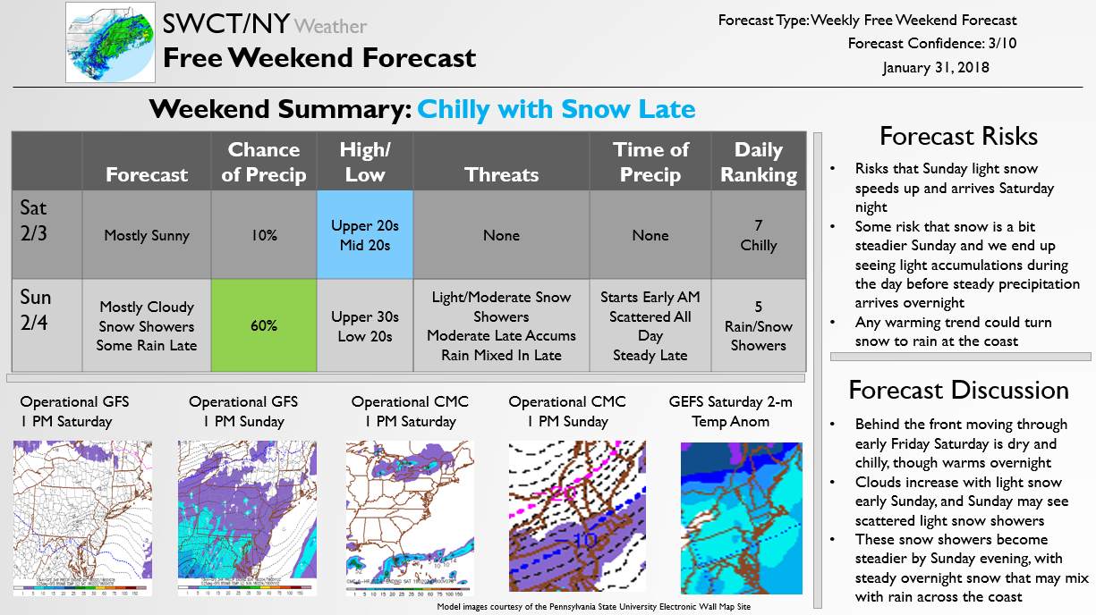
The below Free Weekend Look is published once a week on Wednesdays and outlines our expectations for weather this coming weekend. As can be seen, Saturday should be dry and chilly but we are tracking a winter weather event on Sunday that could impact Super Bowl festivities and potentially school openings on Monday. We will be watching the storm closely and updating Premium subscribers daily. We will send along free forecast updates as well should any accumulating snow remain likely into the weekend, so be sure to stay tuned.

by SWCT/NY Weather | Jan 24, 2018 | Public
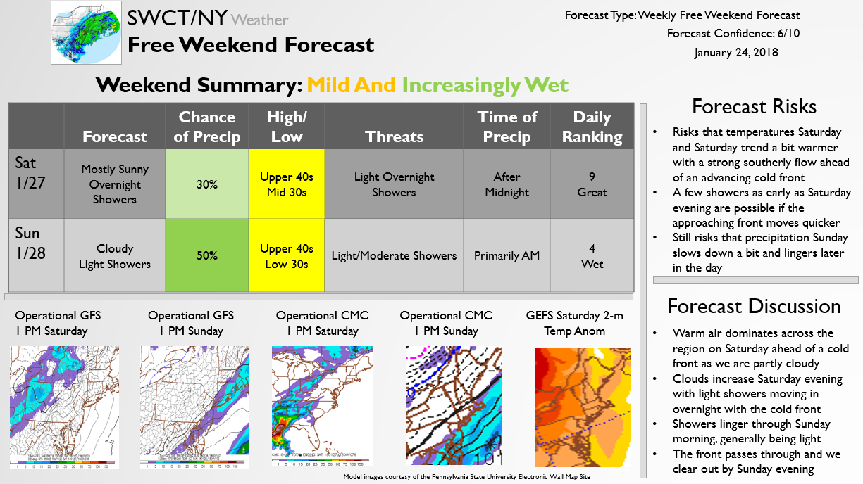
The below Free Weekend Look is published once a week on Wednesday to break down the weekend forecast. We have decent confidence in the forecast for the weekend, with light showers late Saturday night into Sunday morning being likely on an otherwise mild weekend. We are also tracking a light snow threat Monday we have alerted Premium subscribers about, and are looking for a return of more wintry weather into the middle of February, so be sure to stay tuned!

by SWCT/NY Weather | Jan 10, 2018 | Public
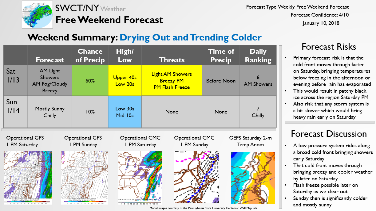
The below Free Weekend Look is published once a week on Wednesdays and outlines our expectations for weather this coming weekend. As can be seen, we see some showers early Saturday quickly moving through as we cool down Saturday night into Sunday. There will be a risk for patchy black ice if cold moves in quick enough Saturday to freeze over any standing water, so be sure to be alert. The forecast for a sunny and chilly Sunday is high confidence.

by SWCT/NY Weather | Jan 4, 2018 | Public
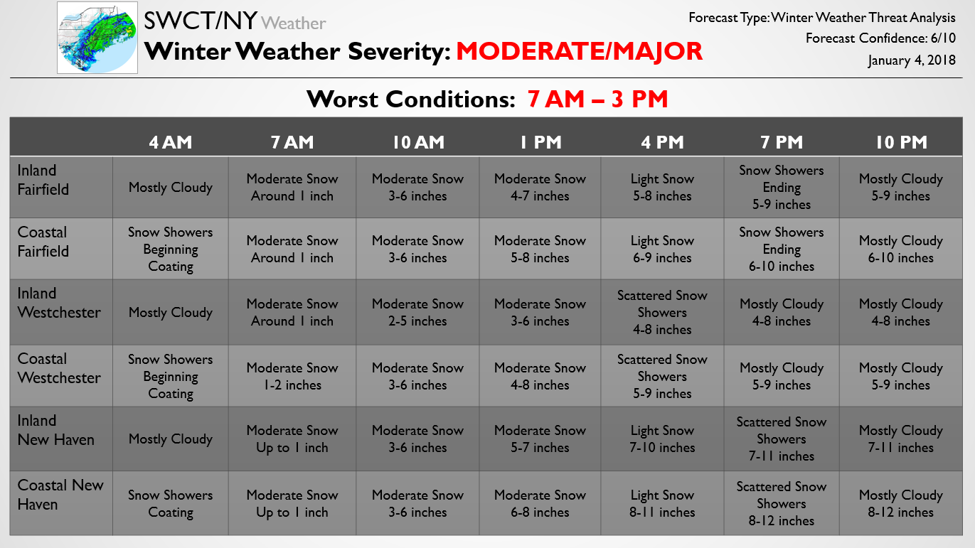
The below forecast was recently sent out to Premium subscribers modifying the timing and accumulation impacts for the storm today. Generally, the forecast remains on track with just a small revision upwards in snowfall accumulations and a slightly longer timing of the storm.

by SWCT/NY Weather | Jan 3, 2018 | Public
The below forecast is one piece of our updated Storm Threat Alert published earlier for Premium subscribers. The below Update goes through the updated accumulation and timing expectations for the snow storm hitting the region tomorrow. The forecast generally remains on track, though has been tweaked a bit with the latest afternoon and evening model guidance. Minor adjustments are still possible overnight tonight into tomorrow morning as we determine where the strongest banding sets up, but the National Weather Service has now come in line with our expectations and models are agreeing more, increasing confidence overall.
Should you wish to upgrade to Premium and receive daily 15-Day forecasts, school and travel impact analysis during storms, and early release of storm forecasts, you can subscribe here.


